|
Chachapoyas & Kuelap
Si Ud. quiere traducir esta pagina a Castellano haga "click" sobre YUPI - Educacion |
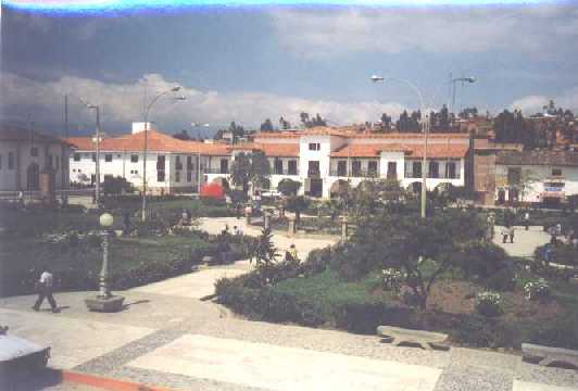  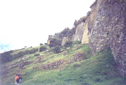 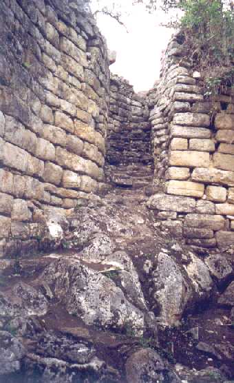 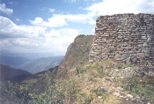 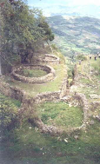  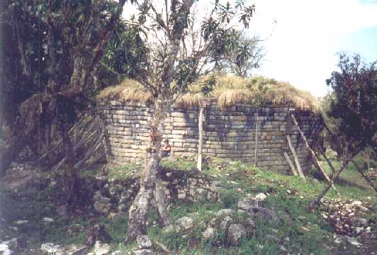 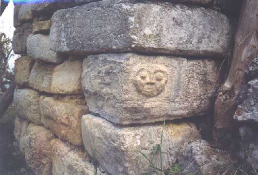 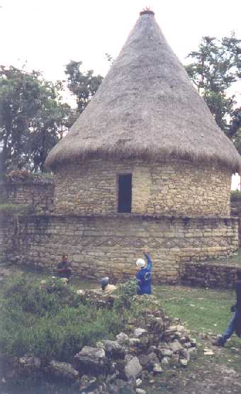 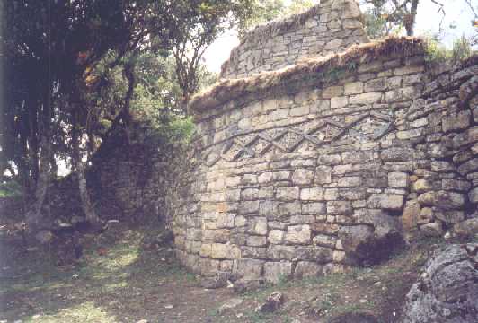 |
Chachapoyas is about 800 km (straight-line) to the north of Lima and I had wanted to go there for some time because I had heard that there was a pre-Inca mountaintop fortress nearby called Kuelap. It was supposed to be on the same scale as Machu Picchu and little archaeological study had been made of the site. Chacha, as it is known, is in the department of Amazonas and everyone seems to assume that because of this name it would be in the jungle. In fact about one third of this department is in the eastern slopes of the Andes highlands with mountains rising up to 4000m and Chacha is at an altitude of 2300m. So, in the second week of October 1999 I set off to find Kuelap. (Note; all the images can be viewed in full by clicking on the thumbnail image. The first image is of the main square in Chacha: the remainder are all of Kuelap fortress.) In order to avoid a long bus ride through the Peruvian coastal desert north up the Panamericana Highway I took a seventy-minute flight from Lima to Chiclayo where I arrived about lunchtime. After hanging around this city for the afternoon I caught a direct bus leaving at 6 p.m. for the eleven hour journey to Chacha. As buses go I have been on worse; it wasn't particularly clean and, as is common, didn't have on on-board toilet (if anyone gets caught short they have to ask the driver to stop and then go and find a quiet spot by the roadside). However, there was a video on board and we had two films in English with Spanish sub-titles. There was a 45-minute stop around 8.30 p.m. at a roadside restaurant but in Chiclayo I had already bought the local equivalent of Cornish pasties as a meal for the journey. After the second video the lights were turned out and everyone tried to sleep as the bus climbed up over mountain passes and down into valleys. I recall the road changed from asphalt to dirt for about the last three hours but of course couldn't see anything out of the bus window. The bus arrived in Chacha at 4.30 a.m. which is no time to arrive anywhere let alone a small rural town in northern Peru. However after the bus had parked, anyone who wanted could stay snoozing on the bus and I was last off at 7 a.m. It was a short walk to the main square where I found the hotel I wanted and got the night staff to give me a room. After a shower and some breakfast I contacted Rob Dover who is an English guy from Bristol married to a Peruvian girl and who is a partner in a trekking and adventure travel business in Chacha. Later we had lunch together and he told me of the interest shown by major TV documentary producers in this area; he had just recently returned from guiding a film crew from Discovery Channel and before that a UK channel. In the afternoon I arranged with my hotel to take a bus tour to Kuelap the next day. Next morning the bus turned out be to be a small 12-seater lacking both in leg-room and width, hence I did not fit too well. Even the Peruvians, who generally are smaller stature than gringos, have trouble squeezing into these. The bus left at 8.30 a.m. and within 10 minutes of leaving the town I had my first experience of local roads; they are narrow, rough, dirt, and with terrifying drops several hundred metres down the steep slopes into the river valley below. (I had travelled up this road in the overnight bus without realising it.) From then on, and for the whole of my time in Chacha, whenever I travelled by road my palms were sweaty. The route from Chacha took us down to the Rio Utcubamba, a height loss of 500m, followed the river going upstream for half an hour then started climbing again and continued climbing for the next two hours along similar rough, precipitous roads. We passed through small villages clinging to the mountainside, over one ridge then into a valley then round another ridge and so on, climbing continually. Finally we arrived at the carpark just below the fortress about mid-day having gained nearly 1200m from the river. From the car park it is about a fifteen minute walk uphill to arrive at the outer walls of the fortress. Gringos have to pay just under US$3 entrance charge to the fortress but for this you get a Spanish-speaking guide (who expects a tip). Kuelap fortress is on a mountaintop at an altitude of 3000m, there are steep cliffs dropping 1200m into valleys to the north and west, a similar but less-steep drop to the east and the approach from the south is along a ridge about 80m wide. There are mountains going up to 4000m on the other side of the valleys. The fortress pre-dates the Incas by several hundred years. It was built by the Chachapoyas who thought it was impregnable but the conquering Incas easily found the weak point - it didn't have its own supplies of food and water - so it fell after a siege. The Chachapoyas got their own back because when the Spanish conquistadors came along about seventy years later they fell in with them and drove the Incas back out! The fortress measures 500m north-to-south and has a total area of about 6 hectares and it is on three levels. The outer perimeter wall varies in height from 10 to 15 metres and is constructed from limestone blocks weighing up to three tons. There are three narrow entrances with steps rising up to the first level. Inside the site there are ruins of nearly four hundred stone buildings; nearly all are circular. Most of the buildings have been demolished down to their foundations; a few remain standing as high as three metres. The second level is contained within another wall 10m high with one narrow entrance. On the third level are fewer buildings but at the north end there is a square tower called Atalaya (used as a watch tower and as a store; excavations revealed 2500 slingshot missiles). At the south end there is an inverted conical building called Tintero and its use is the subject of varying speculation; both human and animal remains have been found there, but there is also a theory that it had astronomical use. There is sorrowful-looking human face carved into a cornerstone. It has been estimated that as much stone went into the construction of this site as was used to build the Great Pyramid in Egypt. About 90% of the site is overgrown with trees and bushes (and an abundance of bromeliads) but the foundations and decorated low walls of the mostly-round buildings have been cleared away and are easily visible. It is estimated that the site was occupied between 800 and 1500 A.D. It had both military and ceremonial use unlike Machu Picchu, which had much greater significance to the Incas. Many human remains have been found in the site. A house has been re-constructed to resemble the original structure as determined by archaeologists, and there was a dig in progress while we were there. Our guide was very conscientious and thorough and we spent about one and a half-hours with him; he earned (and received) his tip. In total we spent over three hours at Kuelap and set off back around 3.30 p.m. We stopped very briefly for a very late lunch at a small village and arrived back in Chacha around 7 p.m. Next day every muscle and joint in my body ached from the hours spent in the bus on rough roads the day before so I spent the day quietly. I discovered that Chachapoyas is a small, quiet, rural market town with very friendly people. Hardly anyone speaks English so my Spanish was stretched while I was there. Very few tourists get to the area and apart from Rob I was the only gringo in town. By asking around I found out that the library at the offices of the government health authority had a PC with Internet access so I was able to fire off a few e-mails for a small charge. I also found the tourist information office down a back street and although it didn't have much in the way of leaflets, the staff were extremely helpful. This whole region is the richest archeological area in Peru and I hoped to see some of the few easily accesible sites (many are difficult to reach). The following day I wanted to go to Karajia where some very unusual sarcophagi containing mummies have been discovered on a ledge on a rockface, but I set off too late. The first stage in getting there was a local bus to Luya (another tight squeeze) but I discovered that rural buses don't run to a timetable; they set off when they are full and I waited in the bus for 45 minutes. By the time the bus reach Luya (nearly one and a half hours over more rough terrifying roads) I realised I wasn't going to have time to get to Karajia so I continued on to Lamud which was the end of the bus route. Here I contacted the local director of the National Cultural Institute, an archaeology professor, who has a small museum in the village. The museum turned out to resemble a junk store with unlabelled artefacts from different pre-colonial and colonial periods all lumped together. However the professor was very enthusiastic and was delighted that someone should come to see his museum. He also showed me his photo albums of the many archaeological sites in the region that he had investigated. The only problem was I understand barely a quarter of what he said; his local accent was incomprehensible for much of the time; I have enough trouble understanding Spanish at the best of times. He refused my offer of a donation to the museum. After some lunch in the village I caught the next bus back to Chacha. The following morning I took a short ride by collective taxi to the village of Huancas - a journey of 20 minutes. The village is semi-deserted with many abandoned buildings and a lot of the fields around the village are uncultivated. It is apparent that much of the population has left due to poverty. A short walk up to a low ridge behind the town brought me to a spectacular view down into a very deep river valley with mountains rising in the distance. The next day was my return journey to Chiclayo. The bus left at 3 p.m. and after descending the, by now, familiar road to the Utcubamba river it continued following the river downstream for the next two hours. Now I was able to see the road that I had travelled five days earlier. At times the steep-sided valley becomes a canyon and the road is actually cut into the rock wall with an overhanging rock roof. Once it goes through a tunnel in the rock that is only just big enough to take the bus. Eventually the valley broadens and this road joins the main asphalt-surface highway connecting the jungle town of Tarapoto with the coastal town of Chiclayo, and after another restaurant stop and two more videos the bus arrived in Chiclayo at 2 a.m. I stayed one day in Chiclayo and went to the Bruning Museum in Lambayeque which houses the treasures of Sipan (the gold and silver artefacts of Sipan match the Tutankamun collection). I had seen them before when they were in Lima two years ago but it was worth the trip to see them again. Some of the most important treasures are on tour so if they come your way it is well worth going to see them. A superb book has been published about the Chachapoyas area; it is called "Warriors of the Clouds : a lost civilization of the upper Amazon of Peru" written by Keith Muscott and published in 1998 by the University of New Mexico Press. It has excellent pictures, well-written descriptions and an extensive bibliography. Look for it in your local library. |
|
Now
carry on travelling to -
Bolivia |
These pages
last revised 18th August 2000.
Homepage URL
https://exilianpe.tripod.com/
Copyright © Exilian, Lima, Peru,
1999-2000